Lodging nearby Hotel Garden Inn
Bangladesh
Lodging nearby Hotel Garden Inn
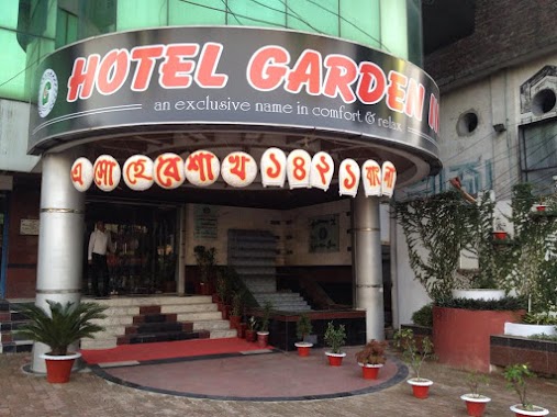
Hotel Garden Inn
সদর উপজেলা, সিলেট, সিলেট জেলা, BD Bangladesh
contacts phone
:
+880 1711-664936
Latitude:
24.8850581
, Longitude:
91.8804152
larger map & directions
read more
nearest Lodging
15 m
Hotel Garden Inn
Garden Tower, Sylhet
Lodging
read more
103 m
Hotel Star
Sayed Burhan Uddin, Sylhet
Lodging
read more
137 m
Al Salim
Chubhani Ghat Road, Sylhet
Lodging
read more
153 m
Rose View Hotel
House-21,Road-22,Block-D, Shahjalal Upashahar Main Road, Sylhet
Lodging
read more
207 m
Hotel Al Salim 1
Sylhet
Lodging
read more
439 m
ছায়ানীড় হোস্টেল
Sylhet
Lodging
read more
450 m
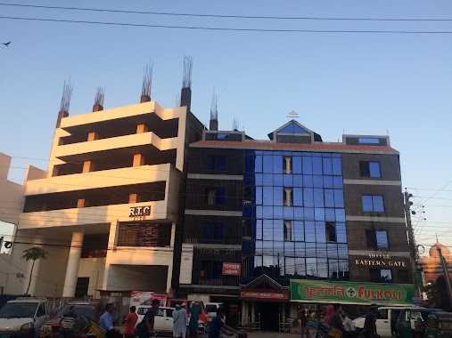
Hotel Eastern Gate
Bishwa Road, Sylhet
Lodging
read more
494 m
Sylhet All Qur-An Memorising Centre
Road No. 1, Sylhet
Lodging
read more
587 m
Hotel Valley Garden
Sylhet Tower, Bishwa Road, Sobhanighat, Sylhet
Lodging
read more
733 m
Kushiara Guest House
Sylhet
Lodging
read more
771 m
Bangladesh Bank Colony Gate
Sylhet
Lodging
read more
771 m
Trivedy House
Kalighat, Amjad Ali Road, Sylhet
Lodging
read more
822 m
Hotel Meherpur Residential
সদর উপজেলা, Sylhet
Lodging
read more
925 m
Hotel Kamran
Mohajon Potti Road, Sylhet
Lodging
read more
934 m
Hotel Sun Flower
Bandar Bazar Road, Sylhet
Lodging
read more
941 m
Hotel Metro International
East Bandar Bazar Dupadighir par (South
Lodging
read more
1.017 km
Hotel Al-Asma
Naiorpool Road, Dhopa Dighir Purba Par, সিলেট
Lodging
read more
1.021 km
Jalalabad College Boys Hostel
House - 26, Shahjalal Upashahar Main Road, Sylhet
Lodging
read more
1.147 km
Hotel Al Foyes
Sylhet
Lodging
read more
1.178 km
হোটেল এমদাদিয়া
Sylhet
Lodging
read more
1.205 km
হোটেল মোহাম্মাদীয়া
Sylhet
Lodging
read more
1.21 km
Hotel Tajmohol
Sylhet
Lodging
read more
1.214 km
হোটেল ফুলমতি
Sylhet
Lodging
read more
1.229 km
হোটেল আল-জালাল
21/c Puranlane N2, Sylhet
Lodging
read more
1.24 km
Hotel Baghdad
Bandar Bazar, Sylhet
Lodging
read more
📑
all categories
Accounting
Administrative area level 1
Administrative area level 2
Airport
Amusement park
Aquarium
Art gallery
Atm
Bakery
Bank
Bar
Beauty salon
Bicycle store
Book store
Bowling alley
Bus station
Cafe
Campground
Car dealer
Car rental
Car repair
Car wash
Casino
Cemetery
Church
City hall
Clothing store
Colloquial area
Convenience store
Country
Courthouse
Dentist
Department store
Doctor
Electrician
Electronics store
Embassy
Establishment
Finance
Fire station
Florist
Food
Funeral home
Furniture store
Gas station
General contractor
Grocery or supermarket
Gym
Hair care
Hardware store
Health
Hindu Temple
Home goods store
Hospital
Insurance agency
Jewelry store
Laundry
Lawyer
Library
Liquor store
Local government office
Locality
Locksmith
Lodging
Meal delivery
Meal takeaway
Mosque
Movie rental
Movie theater
Moving company
Museum
Natural feature
Neighborhood
Night club
Painter
Park
Parking
Pet store
Pharmacy
Physiotherapist
Plumber
Point of interest
Police
Post office
Premise
Real estate agency
Restaurant
Route
Rv park, camping
School
Shoe store
Shopping mall
Spa
Stadium
Storage
Store
Subpremise
Supermarket
Taxi stand
Train station
Transit station
Travel agency
University
Veterinary care
Zoo
administrative area level 3
sublocality level 1
↑